Search the Community
Showing results for tags 'import'.
-
I've tried both draging an image into Autocad and importing it in as a block. When I try to rotates the image it either rotates around a point (but doesn't actually rotate itself) or rotates and disappears only leaving a white outline. How can I properly rotate an image?
-
How do I move point from one file to another in Civil 3d? Copy/Paste won't work. I need to import them to the second drawing somehow. Thanks.
-
Hello All, I am looking for a quick way to take x,y coord. from excel and import them into autocad. I have read something on the MULTIPLE POINT command but everytime I go and put the space in between the words it enters in multiple then point. I only have 10 data points but a lot of sets of points. Thanks,Luke
-

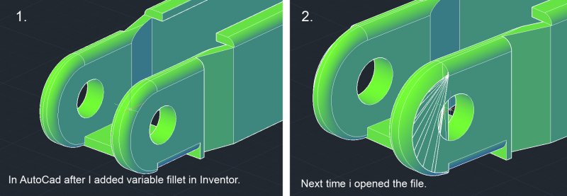
Problem with 3D model exported from Inventor
Arvid93 posted a topic in AutoCAD Bugs, Error Messages & Quirks
I worked with a 3D model in AutoCAD 2012 and then I wanted to add some variable fillets so I saved the part to be filleted as a block and the opened it in Inventor 2012 using Open > Import DWG. I added the fillets and then I used the "Export to DWG" command. I inserted the part in AutoCAD again using "Insert". I exploded the block to a 3D solid and everything looked fine but the next time i opened the dwg file it looked weird at some places (see picture). Does anyone know why this is happening?
-

Importing Coordinates (or Dimensions) from MS Excel 2007 to Autocad 2008
sublettch posted a topic in AutoCAD Drawing Management & Output
Hello, I am designing a RCC Dam and the shape of the dam is constant and will not change, but the dimensions of this shape are very likely to change depending upon hydraulic analysis. I have written a program (irrelevant, but I am using MathCad 14) that performs a stability analysis of a RCC Dam (based on elevations from the hydraulic analysis) and then exports the dam dimensions and coordinates to Excel. I am attempting to then take those coordinates (or dimensions) from Excel to create a 2-D dimensioned drawing of the Dam in AutoCAD. I have successfully linked the Excel spreadsheet containing these coordinates and dimensions to AutoCad tables in my drawing, but I am having trouble getting AutoCAD to update my drawing as these tables update with different coordinates and dimensions. I would like to have a drawing that is fully dimensioned (as the shape of the dam will not change), but that will update coordinates and dimensions as I pump out different dam dimensions from my stability analysis. Hope this makes sense, let me know if anything is unclear. Thanks!, Sublett -
Hello community! First post ever. I've been spending so much time trying to figure this one out that I kind of gave up. Now I need your help. I have 4 computers sharing tool palettes on a network. Whenever a user updates the palette with a new block, he has to export the .xtp file on the network and every other users has to reimport the palette in order to see the changes. We're in the middle of a big clean up since we just got our new Autocad 2011 license and the palettes change pretty much every day, whenever we find time to reorganize it. Is there a way to skip the export/import part when modifying a tool palette? I mean we are all using the file on the network right, so why doesn't it update on modification? At first I thought the palettes would update on startup, at least, but it seems that every single user has to export first and then import the .xtp file every morning or so. It feels like once the palette on the network has been imported, the modifications we apply on the said palette are local, as if autocad would copy the one on the network instead of running it live, which makes it harder to keep it synchronized on every machine. I'll stop my post here because I don't want to further confuse anyone. I hope the problem's clear. I hope there's a way to work around that export/import sequence and get this whole palette thing to work in sync. Thanks for reading this, any help is appreciated
-
hi friends, Iam using auto cad 2010 and i used to make a building in 3d.Is it possible to import doors or windows for other software like 3ds max10, archi cad12 to autocad 2010.
-
I have a base drawing that I am using to create a set of construction documents. I also have 30 other drawings that are generic construction details. I want to import those 30 other drawings into the base drawing as XREFs so that when I update the "other drawings", it will be updated in the base drawing. The problem I am having is that when I import the "other drawings" it imports what is drawn in Model Space. I would like to import what is actual shown in the Plot Page (ie-I want to import exactly what is would print out if I printed the "other drawing") I think the problem is I have some items that are in Paper Space and some that are in Model Space. Is there a way to import both? thanks.
-
I am currently modelling in two packages, a piping package called PDS which is an Intergraph package. i import these files into Navisworks via an nwc file, no poblem there. it interact correctly with this model. form this i can read the pipe sizes specs etc. in otherowrds it is not a dumb model. When i import the Revit model via the same method. and when i run a clash report beetween the tw, the revit model will trow up two clashes per actual clash. in other words when say a pipe penetrates a wall (a hard clash) it should only really detect it as a single clash (pipe v wall). However, it detects the front face of the wall and the back face of the wall?! Has this happend to anyone out there, and if so have you solved the issue or is it a software glich? Any input on this would be greatlly appreciated Regards Diarmuid
-
Hi, I have a csv file that has let,long,meters and was wondering how to import it. I'm thinking there would be a script that would read it in the csv and show the lat long and meters. Been searching a bit now, it seems to be quite complicated. Using Autocad Architecture 2010.
-

Import page setup information automatically
hosannabizarre posted a topic in AutoLISP, Visual LISP & DCL
Currently I use a lisp file to import page setup information, which brings in previously configured plot set up information (as found in a specified drawing template). page_setups.lsp... (DEFUN C:PSN () (command "._-PSETUPIN" "W:/Library/Acad Setup/Page_Setup_Template/page_setup_template.dwg" "*")) Although I have "page_setups.lsp" identified in my startup suite of applications to load, I still have to type "PSN" to import page setup info. Typing these three letters is tiring my fingers out. Can I build the import instruction into accaddoc.lsp so that I don't have to keep typing PSN, so that it autoloads (and imports) with every session / drawing?? Cheeeeeeeeeers, hosannabizarre -
Hi all! I'm new to Map 3D 2009 and having trouble referencing a PDF that I need to trace for my new job. I couldn't quite figure out how to import a PDF for an underlay, so I've used Photoshop to convert it to a TIF image (seems easier to find an import command for this file type.) When I select "Insert an Image..." from the Create menu, the image is rendered OVER my dwg drawing. I can't really see the map now and it seems this isn't the best way to accomplish what I'm needing to do. Anyone have a suggestion of a better approach, or maybe something I'm overlooking in my procedure? I would really appreciate your feedback!