Search the Community
Showing results for tags 'terrain'.
Found 7 results
-

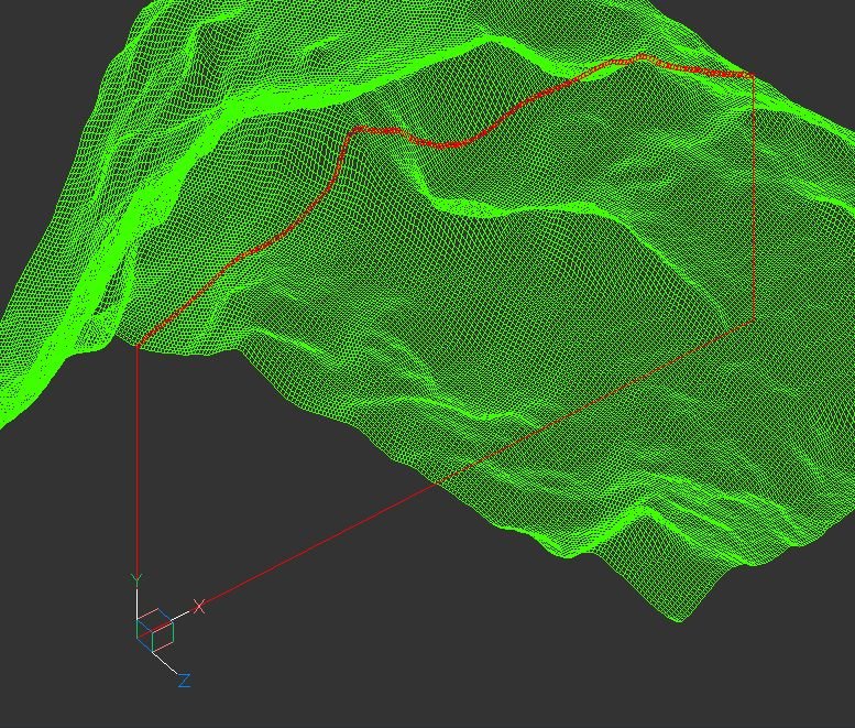
terrain Cross section of the 3D terrain
Andrej Skvarca posted a topic in AutoCAD 3D Modelling & Rendering
Hi guys, I've created an AutoLisp app which creates a cross section of the 3D terrain grid. The terrain can consists of raw AutoCAD entities: MESH / POLYFACE MESH / POLYGON MESH (one or more, even combined). As an author, I will be grateful for any comment, especially suggestions for improvements and developments. Andrej Skvarca TERRAIN_CROSS_SECTION.fas
-
Hi. Is there a simple way to quickly draw a mesh out of the following splines created from a recent survey to represent a terrain. Note some data are missing. Thanks. Terrain.dwg
-

Help! 3D model not watertight / converting surface to solid / terrain modeling
zjkaufman posted a topic in AutoCAD 3D Modelling & Rendering
Hi all, I am having urgent trouble with a project involving 3d modeling of terrain. This is a graduate-level project requiring ArcMap and Star-CCM+ software as well, which I am capable in, so I overlooked taking on the responsibility of modeling in Civil 3D (which I am a beginner at) and converting file formats. I was hoping one of you had some suggestions. I am attempting to turn an elevation model of the island of Jerba into a 3D CAD model for use in computational aeroacoustic modeling (any of the typical file formats - .igs, .stl, etc. work for importing the model). I brought the data into Civil 3D 2014 as TIN Triangles, used convtosurface, and attempted to export as an igs. The export functioned but the file won't import into the other program because it requires a watertight solid geometry. I have tried surfsculpt and convtosolid as well as to create a mesh but I am sure I am giving it invalid commands because it keeps crashing the system. Please help! This project needs to be done asap and I am utterly lost. Also not working for me is the manage attachments section on this forum so I have uploaded the files to an open google drive folder: https://drive.google.com/folderview?id=0B6zt3I2EQtAVRHJ4QmVJVW1NUUE&usp=sharing I have attached the .dwg file I have been working in (FromIGS_WithSource.dwg) as well as the original exported TIN triangle file (ZJKCAD4_4_2.dwg), the non-functioning igs model (ZJKCAD4_4_2.igs) and the raster grid file of elevation (whole elevgrid folder) in case any file is more helpful. I have access to Civil 3D 2014 and AutoCAD 2014. Please don't hesitate to let me know if there's any additional information I can give you. Thanks in advance! Zach -

How to create surface or solid from contour lines?
mihailklenov posted a topic in AutoCAD 3D Modelling & Rendering
Hello, there! For several days now I've been trying to lay a mesh on top of some contour lines. I've also tried the loft command, but with little success. I've tried several terrain plugins, but they all seem to misfunction because I have overlapping contours. Here is the dwg to get idea what I'm trying to make. I'll be very grateful to all kind of suggestions on how I can do it. (including recomendations for plugins, other software or whatever else) Thank you in advance! contours.dwg -

Creating Terrain from 3D polyline (Loft?)
janetengo7 posted a topic in AutoCAD 3D Modelling & Rendering
Hi, I'm new to this forum as well as Autocad. I'm currently facing this problem of lofting/elevating the drawing. The drawing had all the 3D polyline and I need to join them. I have no problem joining a 2D polyline, but now i'm facing this problem. see attached. Please help~~ Much thanks in advance!
-

Creating a surface or solid from a Contour Map?
Sian posted a topic in AutoCAD 3D Modelling & Rendering
Hi, I have a contour map in polylines in the correct elevation and I was wondering how I can make it into a surface? I have read many threads and searched the AutoCAD Architecture 2010 user documentation but cannot find a "drape" command which everyone seems to suggest from other peoples posts. The map is quite detailed therefore the Edgesurf, Rulesurf etc won't work or I can't seem to get it to work! Any help would be very grateful! Thank you, Sian -
I am looking for a routine to sort contour lines. I am using 3d polylines that I import from Global Mapper. My problem is all of the lines are on one layer. Ideally, I would like to pick a starting elevation (polyline) and have the routine select every 5th contour up and down. Once then are all selected, I can move them to a new layer (like TOPO-INDEX). Some of these sites are hundreds of acres and have significant elevation changes. To do this by hand is VERY time-consuming (and easy to miss some contours). I am not a programmer, but this seems like the type of task that is ideal for a lisp routine. Any help is appreciated.