Search the Community
Showing results for tags 'kml'.
Found 4 results
-
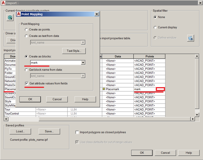
I need to figure out a way without using any third party software to bring in a ZML or KMZ file from Google Earth into my project showing both the placemark and name. I've trying creating a block with an attribute then using MAPINSERT command with the following attachments but can not get it working. The final output I require is a Civil3D point with the proper coordinate and name.

-

DWG to GE w/line styles
Squirltech posted a topic in AutoCAD 2D Drafting, Object Properties & Interface
So, we have a SUE department and they use all sorts of line styles, example: -----CaTV D-----. The issue is that when exporting to a KML/KMZ file using GE Pro, the lines display in GE as solid lines. Going from Microstation to GE, the line styles display just as they do in the dgn. Anyone know any information about this or a way to resolve it? Currently, we're going from Acad to DGN to KML/KMZ to get the line styles to display. Thanks in advance! -

Extract coordinate data from AutoCAD
ahmerjaved posted a topic in AutoCAD Drawing Management & Output
Hello all, I work in a manufacturing facility and we are trying to come up with a way to extract data from an AutoCAD file in to a .KML or .CSV file which gives coordinate points, etc. This will be used in a mapping-type software to display/highlight areas of the plant with zooming capabilities and information shown on the left-side. We are trying to make it look something like Google Maps, so it can used to determine areas of the plant undergoing work, lighting zones, etc. We are in the preliminary stages of this project and I could use some help/advice on how you guys would approach this. I have intermediate AutoCAD knowledge, hence I am reaching out to the community. In a nutshell, I want to be able to extract coordinate data from our layout(s) which can used to pinpoint locations on the map and highlight regions, etc. Perhaps it could export data in to Excel with attributes assigned to the coordinates which give Area, Bay Location, etc. The initial thought was to somehow export this to a .KML file and use that as a starting point. Let me know what you guys think, and how to best approach this. Any help would be greatly appreciated! Thank you. -
working with Land Desk Top 2002, need to export boundary lines to KML for use in Google Earth, found a .shp converter to kml (is is not working I don't believe it is picking up the coordinates to place correctly in G-Earth). was hoping any of you may be able to help.