Search the Community
Showing results for tags 'points coordinates'.
Found 4 results
-
I was given a document (not a point file) of lat and longs, is there a way to create a points using LAT LONG instead of northing and eastings? I can't seem to find anything on this. I created a new .txt file using the lat and long but it only seems to recognize northing easting. Which in turn brings the points in close to 0,0 and not the coordinates it needs to be in. Thanks! I am currently using Civil3D 2015
-

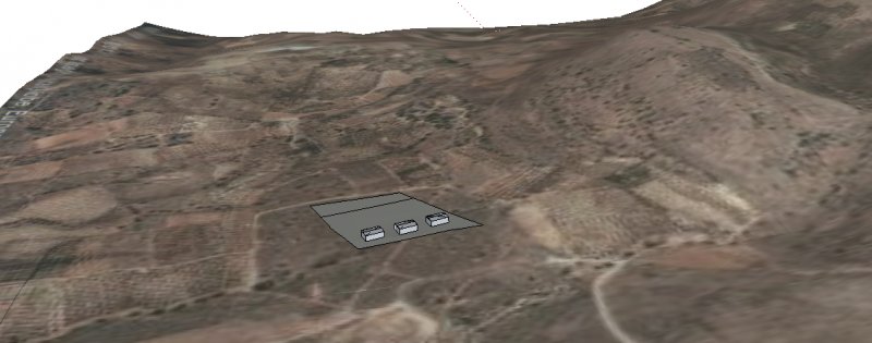
XYZ points -> to solid - > with image overlay
Cris- posted a topic in AutoCAD 3D Modelling & Rendering
Dear Friends, I need your help with the following case. I have a XYZ table which is coordinates and elevation. When plotted in 3D in Matlab or Excel, it results in a 3D surface plot which shows the topography of an area. My end goal is this: (1) create a solid object with these coordinates, (2) overlay the object with an aerial photo and last (3) design some machinery/buildings on top of it. In short, I want to do the Autocad equivalent of the Geo-location operation in Sketchup (see attached image). If I understand correctly, I need to first create an STL file and import it in Autocad. Then I need to convert it to solid and last, I could use SUPERHATCH to attach the aerial photo. Fyi, my tools now are a vanilla Autocad (not Map etc) and MeshLab. Also I could use 3D Max if needed for conversions. Please note the peculiarity of an XYZ object representing topography. I had created an STL file in Meshlab for these points and imported it in Autocad but the convert-to-solid command could not do the job. I imagine it had to do with the fact that it was effectively a layer with no thickness. As a newcomer, I mostly need help in correctly formulating the problem (ie using correct terminology so that my google search is well focused). Ideas welcome. Many thanks, Cris
-
Working in VBA for AutoCAD 2016 and I cant seem to figure out how to extract coordinates from a point in an open, active drawing. Any help would be much appreciated. Thank you.
-
I was wondering if someone could help me with a lisp to draw a spline and get the coordinates of the first two points of the spline. I need them to insert a block in the first point of the spline and to define the angle between the points. I started with the lisp below but I can't make it work properly, the command prompts are different from the prompts for the standard AutoCAD spline, it promts for and . I have to hit ENTER a few times to exit the program. I am using AutoCAD 2011. Thank you. (defun c: DrawSpline () (command "._spline") (while (> (getvar "cmdactive") 0) (command pause) )