Search the Community
Showing results for tags 'gis'.
Found 7 results
-
I have a line that crosses through multiple polygons. Is there a LISP to give me a count of how many polygons this line goes through?

-
Hello all, I'm looking for some way to convert ESRI ArcGIS geodatabases and/or shapefiles into CAD linework using vanilla AutoCAD. In my office (petroleum industry), we use utility data, parcel and ROW data, and topo data (especially contour lines) the most, so these categories are the stuff we would be importing into CAD the most. Now, due to how rarely this issue comes up at my workplace, I can tell you that I will never get authorization to buy a Civil 3D or Map 3D license, nor will I ever get authorization to buy any third party conversion software that is more than about $300 (I've been begging for a $300 copy of Manifold for months now to no avail). I had found and downloaded an add-on from somewhere, and although it worked occasionally, it still couldn't handle .gdbs but only the older shapefile format. I also tried ESRI's ArcGIS viewer for ACAD but that seems to only allow viewing- not export or manipulation of data. Does Autodesk or ESRI (or any third-party developers for that matter) offer any affordable add-ons that would allow us to convert shapefiles and or geodatabases into vanilla AutoCAD 2014/15 linework?
-
Using this tool, I was trying import the Parcels in C3D into the SDF but every time I do it I only get Parcel Name, area and perimeter. I need the parcel number too but it is not exported. Is there an ini configuration somewhere to turn on export for these attributes? Using C3D 2013 32 and 64 bit versions.
-
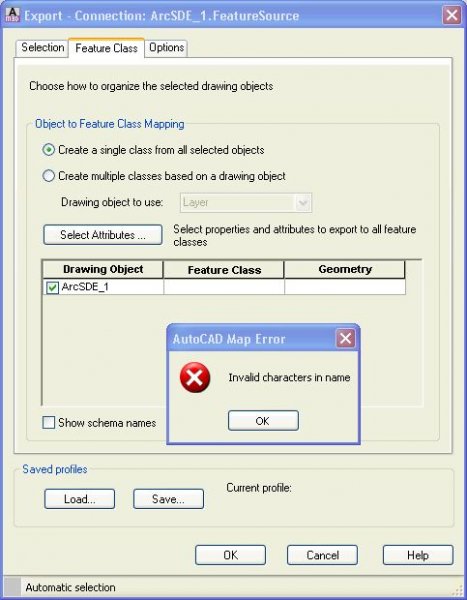
I'm getting better with using GIS in CAD. Right now I'm at a dead end with the MapExport to FDO using an ArcSDE connection to an existing SDE connection. After selecting my ArcSDE connection, Export: Connection to ArcSDE dialog pops up, I can't see my feture objects that are connected on the map. I get the error :invalid characters in name. No feature class appears in the drop down. I feel like I'm close to making this work. When I click on Okay without any feature class selected A Map Export window pops out that is empty.
-

Set Map 3D back to default
alster5356 posted a topic in The CUI, Hatches, Linetypes, Scripts & Macros
hey guys, I have map 3d 2010. when i was trained on this software i used the default ribbon based work space. our boss had someone come in to the office and standardize everyones workspace, which is great, as long as i'm just doing drafting. the new way it is set up is similar to AutoCad classic. but when it comes time for me to do any sort of GIS work, i can no longer get back to the ribbon based workspace. i CAN get the ribbon to come back, but when i do, it is empty. it says "the ribbon does not currently have any tabs or panels loaded." how can i get my default ribbon workspace back, without losing our, company standard, drafting workspace? i realize i need to set up a new workspace, i just have no idea how to go about getting all of the ribbon tools i'm used to. (default) any ideas? -
Two Questions: 1) can i import shape files into the same .dwg file using two separate coordinate systems? ie: WGS 1984 (LL84) while the majority of my data is on the IL83 coordinates? 2) Once the 'draping' of my files have been placed over the ariel image file for the terrain, can I use map to do a 'flyover type animation' or would I have to move on to something more complex such as Max? Thank you. Bob
-
Hi, I'm relatively new to CAD, but experienced in GIS. I am trying to import a survey drawing from CAD to ArcGIS (Version 10 Editor). When I import it seems to import all layer types except for ACC_Parcel_segments. It will import polylines, arc, circle etc. I have stumped the GIS pro at ESRI, and am waiting for a response from AutoDesk support. Any ideas? R (sorry if my terminology is all wrong)