Search the Community
Showing results for tags 'xref'.
-
I received this from GSA (US govt agency) as part of a larger program to help set files to their standards. This portion doen't seem to work - does not set the path. I have tested various parts, but can't see where it is failing. If anyone could have a look and tell me if anything looks wrong I would appreciate it. Any suggestions welcome. Thanks ; remove xref paths ; select the first block (progn (setq blk (tblnext "BLOCK" 1)) ; repeat for each block definition in the drawing (while (/= blk nil) ; determine if the block is an xref (setq groupcode70 (cdr (assoc 70 blk))) ; determine if groupcode70 contains a bitwise 4 ; this would indicate it is an xref (if (= 4 (logand 4 groupcode70)) (progn ; if groupcode70 contains a bitwise 32 it is resolved (if (= 32 (logand 32 groupcode70)) (progn ; it is resolved ; strip out path if present (if(setq xrefname (cdr (assoc 1 blk))) (if (wcmatch xrefname "*\\*") ; change the old name to the new (command ".-xref" "p" (cdr (assoc 2 blk)) (strcat (vl-filename-base xrefname)(vl-filename-extension xrefname)) ) ;end command )) ;end if ) ;end progn (progn) ; xref is unresolved - do not try to change it ) ) (progn) ; the block is not an xref ) ; select the next block (setq blk (tblnext "BLOCK")) ) );_end progn
-
I am getting an error mesage on my Autocad system. Actually a couple of them. Says: Duplicate version of TCAD not recconised. Unsure of TCAD version. Duplicate version of TCAD ignored. And on and on, for numerous times... Such is what shows up after I then XREF'd in a group of little drawings into a certain plan. Now have obtained a few wing ribs from someone last year, and they may have been done via Turbocad. I also have gone direct to the little drawing file, and to the TCAD web-site, and nothing.... Got any idea as how to remove the error message(s)? Wm.
-

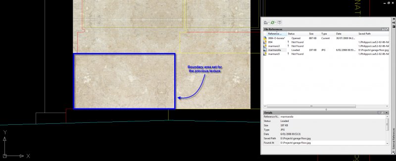
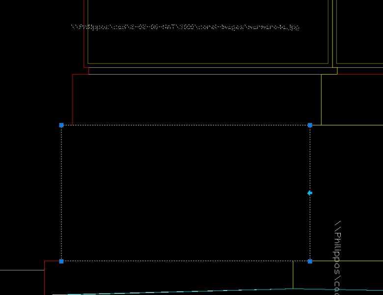
Lost boundary while changing the attached image
gpktm posted a topic in AutoCAD 2D Drafting, Object Properties & Interface
Hi everyone. I was making a facade in ACAD but I acciddently deleted from my hard disk the attached images I used for textures. So, I decide to replace them with another similar texture, but, while I change the path of the file I lost my boundary area. Does anyone know why is this happens? Here is a snapshot with the missing texture And here after I replaced it
-
I have a base drawing that I am using to create a set of construction documents. I also have 30 other drawings that are generic construction details. I want to import those 30 other drawings into the base drawing as XREFs so that when I update the "other drawings", it will be updated in the base drawing. The problem I am having is that when I import the "other drawings" it imports what is drawn in Model Space. I would like to import what is actual shown in the Plot Page (ie-I want to import exactly what is would print out if I printed the "other drawing") I think the problem is I have some items that are in Paper Space and some that are in Model Space. Is there a way to import both? thanks.
-
I have been fighting with this for some time now: In a drawing that containes blocks with attributes, blocks with blocks with attributes AND xrefs with blocks with attributes. I need to extract some attributetags AND the X, Y and Z-coordinate. With ATTEXT and a filterfile I have got it working, BUT... Sometimes the ATTEXT-file that is created displays some strange values in the coordinates. Sometimes numbers are very small or very large, but the XREF-drawing shows no entities on that coordinates. For example 3.277566e-99 of 4.19987e125. These numbers cannot be transferred and used for the rest of the program. How can I fix this so it reads the real coordinates from the XREF/block and not some strange 'mutant'-code???