Search the Community
Showing results for tags 'app'.
-
Hello everyone, I'm wondering if it is possible to create a lisp that could attach several images to AutoCAD 2010 at the same time and create a new layer that has the same name like an image for each image. I downloaded georefimg app that put an image in certain place in AutoCAD based on world file but it is necessary to do this for each image separately. In case of this app first thing to do is attach one image to CAD and afterwards I can use georefimg to choose an image (that was inserted before) in order to put this in proper section. But it could be faster and more efficient if I would attach many images equally in random place and after that use this georefimg for all images. If someone has some idea how to prepare sth like this I'll be grateful for any suggestions in this case. Best wishes, Jakub
- 17 replies
-
- app
- georeference
-
(and 2 more)
Tagged with:
-
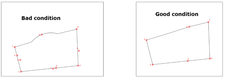
Colleagues, best regards. Today I come to ask for help. I have developed a routine that splits a polygon based on the location of the origin of the blocks above it; However, the selection takes into account other blocks that overlap only slightly in the polygon, allowing me to run the routine anyway but with an undesired result. I can remove the blocks manually, but when there are too many it becomes very tedious and time-consuming. I want to know if there is a way to avoid these external blocks that alter the results of my routine. In the attached dwg I present 2 cases, in the one on the right the routine works without problems, however in the one on the left the complication occurs with the blocks external to the polygon but that still overlap a little. Another complication that arises is when the polygon presents an arc. Attached dwg and lisp file I am very grateful for the help and attention provided. ORIGENpl.lsp SEGMENTACION.dwg
-
Been browsing through the AppStore and came accross a few which apparently view dwg and dxf files. Has anyone/does anyone use any of these, what do you make of them and which is the most AutoCAD-like? I want to get one, it looks handy to have on site when last minute changes are made, may even speed up the whole process of change. They're way over the 59p mark so need some decent advice as to which one is actually worth while installing. Cheers the_phil
- 5 replies
-
- iphone
- application
-
(and 3 more)
Tagged with:

