Search the Community
Showing results for tags 'plan'.
Found 7 results
-

Version 1.0.0
783 downloads
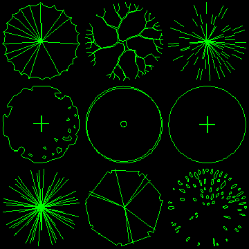
2D Tree Symbols (Collection 1) The plan tree symbols in this pack are compatible with AutoCAD Release 14 and higher. All drawings are relatively small (25-30KB) and are suitable for use as blocks within AutoCAD. They are ideally suited for Landscape Architecture planting plans. The trees have been drawn with a radius of 1 drawing unit. To insert a tree at the required size, simply enter the required radius as the insert scale factor. The trees are all drawn on layer 0, this means that they will adopt the characteristics of the current layer when they are inserted. It is advisable therefore, to create a new layer before insertion so that you can easily control object properties. In each case, the insert base point is in the centre of the canopy. -
Version 1.0.0
2,980 downloads
2D Tree Symbols (Collection 2) The plan tree symbols in this pack are compatible with AutoCAD Release 14 and higher. All drawings are relatively small (25-30KB) and are suitable for use as blocks within AutoCAD. They are ideally suited for Landscape Architecture planting plans. The trees have been drawn with a radius of 1 drawing unit. To insert a tree at the required size, simply enter the required radius as the insert scale factor. The trees are all drawn on layer 0, this means that they will adopt the characteristics of the current layer when they are inserted. It is advisable therefore, to create a new layer before insertion so that you can easily control object properties. In each case, the insert base point is in the centre of the canopy. -
Hi i got a plot plan to redraw in autocad, but something looks off with the bearings. I know bearing usually looks like this S30D57'08"E but the bearings on the plan looks like this N19d36'47" there is not direction at the end of it.
-

Planning Permission Drawing CAD book
dfooty posted a topic in AutoCAD 2D Drafting, Object Properties & Interface
Hi, I need to start drawing 2d floor plans and house plans for extensions. These need to pass planning permission so I am assuming that walls need to be a certain thickness etc. I was wondering if there are any books out there or any guides which can show me step by step how to produce a plan which can be passed by planning? Thanks, -

2D Plan and Elevation to simple 3d model? Revit perhaps?
reyna12 posted a topic in AutoCAD Beginners' Area
Hi there, I have a 2d plan and several elevations/sections and was wondering if it was possible to do a quick mock up of what it would look like in 3d? Load drawings and just extrude somehow, or even import them in to revit? Im pretty new at all of this so hopefully there is a simple method? Thanks for your help. -
Hey all, I'm setting up some plan and profiles (I DON'T HAVE CIVIL3D) with MAP3D. I have a couple of autolisp routines to help with the profile grid, but one thing that confuses me, the grid should be in paper space and the vertical scale set based on paper space, right? I'm assuming that the actual contours/polylines (once I have them georeferenced) will go in model space. Thanks for any tips,
-
I'm fairly new at drawing site plans. I can do a square site plan fine but now I have to put a house on a lot with a arc front. The cooridinates are S4d54'02E on the west side with a length of 108.54'. The back is n87d58'41"E with a length of 113.21. The east side is N25d53'25"E with a length of 118.29'. The front of the house has the arc and all it says is curve 18. I have the three sides but don't know how to get the front. The information on the curve is: Length-55.31' Radius-50.00' Delta - 54.09' Chord direction - s83d44'48"W chord length - 52.53'