Search the Community
Showing results for tags 'civil 3d'.
-

Creating a surface model in Civil 3D from existing 3D polylines, lines and points
0misclose posted a topic in Civil 3D & LDD
Hi all, I'm quite new to Civil 3D and I've tried to have a look online to find what I'm looking for but I feel it might be easier to just ask. I'm wanting to generate a surface model of a complex feature survey which I currently have in AutoCad. All the 3D linework for kerbs, retaining walls, footpaths etc. as well as spot heights are already in the AutoCad file (due to the nature of the project the workflow isn't very nice and predominantly involves DXFs which are then stitched into the main file and the layers are adjusted afterwards). I don't have any codes or data input workflows setup within Civil 3D. I have another survey software package that I normally use to generate my surface models but it will be very time consuming to import the DWG and set it up beforehand due to the scale and amount of breaklines so I was curious if it would be easier for me to try and do it in Civil 3D (it might not). How easy is it to take 3D polylines, splines, lines and points from a DWG and generate a surface in Civil 3D? Is it possible to select all the lines and ensure they are breaklines? Are you able to make select layers non-contourable? How easy is it to generate model boundaries? I would greatly appreciate any guidance. Regards, Ryan -
It sounds so simple, doesn't it? Points and point labels (and a lot of other objects) have a default style. I would like to edit that style or make a copy of it or both. You can open a dialog box to "Edit Label Style Defaults" for points. There are multiple ways to get there. The problem is, the properties you can change in that dialog include everything except the contents. That's what I need to change: just take out one of the components. Without the ability to see the components of that label, I can't duplicate them in another style. For some reason I can't copy the <default> style, either. Is there some simple mechanism that I'm overlooking? Or is this one of those simple tasks that is impossible in Civil 3D?
-
One of our most tedious and common tasks is labeling swales. You draw a polyline, you add a few elevation markers based on the design surface, and that's about it. So it would be nice if we could write a program for that. Plus it would be nice if it's easy to maintain. According to my research, though, that's a tall order. The only languages that let you drill that deep into Civil 3D have to allow .NET or COM, and that means you have to install Visual Studio. I'd rather not do that just to create and maintain one app. Does anyone know of a way to access Civil 3D surfaces and create elevation labels using AutoLISP or some other interpreted language? Python, maybe? Not asking for code, just a more suitable way to write it.
-
We often have ditches in roadway cross sections. I create a feature line to model the bottom of the ditch, so that there's a target for the slope into the ditch. My question is, is there any way to specify a point by providing a station and an offset off the road alignment, so that I can place the feature line nodes accurately? What I've been doing is 1) draw a series of circles centered on where the sample lines cross the centerline; 2) draw the feature line with each vertex at the intersection of a circle and a sample line; 3) provide the elevation based on the elevation needed in the cross section. Yes, it would be more efficient to draw one long segment and let AutoCAD extrapolate the elevations, but our ditches never line up that neatly. A better question might be, is there a more efficient way to create a ditch in cross sections? Up until now, we've been doing all this by hand. Judging by the lack of discussion on this particular item, it's so easy nobody has problems, or they're doing it manually too.
-
Hello, I have users that are running 2018 without issue and the same users also have 2021. Geolocation works fine with 2018 but with 2021 their 360 login name is present but geolocation will not load maps. Opening the same file in 2018 works fine. The other item is when the pull-down is selected next to their sign in name the only two options are: Explore Purchase Options and Manage License. The two options above, Sign Out and Account Details are not displayed. Any help is greatly appreciated. Thanks, Phil
-
Hello all. Got a bit of an odd one. Just got a new laptop with Civil 2021 (version 2021.2) Everything works as expected until I try and open a drawing with previously created Pipes using Pipe Networks. Once I open the drawing I can see everything but it always just hangs and Civil stops responding. No Fatal errors it just never fully opens. I've waited over 40 minutes for the drawing to respond but it never does. This happens on any drawing I try to open with Pipes. These are drawings I've created that have worked fine on my previous computer with Civil 21 installed. this even happens on drawings created in previous versions. Thanks for aby input!
-

AutoCAD Civils not showing enough minimum and maximum ranges
Nellie posted a topic in Civil 3D & LDD
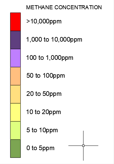
Hi, This problem keeps popping up for me, not every time but I really want to understand why the error happens. I am using AutoDesk Civil's 2020 and trying to create a heatmap from data picked up on site by a GPS gas reader, the data needs to be shown in 8 ranges of set readings ranging from green to red but for the last two sets of reading CAD will only offer me 5 or 2 sets of readings instead of the 8 that I need no matter what I do. Seeing as this doesn't happen every time along with the fact that its the same kit that captures the readings the error or setting issue must be in CAD, I have used different drawings but still no luck. I have attached a screen shot showing CAD only offering 2 ranges instead of 8 even though I have input the maximum of 200 along with a screen shot of what the ranges should be and the data I have used. Any help or advice on this would be much appreciated. Cheers Amended.csv
-

civil 3d Is there a lisp routine to move text to block base point?
CADman123 posted a topic in AutoLISP, Visual LISP & DCL
I want to move text to the nearest block intersection point so i can build 3d models from text. Without this my text is not bang on the marker. -
Ever since installing the 2019 version of Civil 3D, my command window will not stay docked. I am asking for help at this point because I do not know what else to do and have scoured the web in search of answers and have tried just about everything I can think of. Before all the usual suggestions come pouring in, here's what I have tried so far: (1) I changed STARTUP to 0 and docked the command window. This did nothing. (2) Next I locked everything. LOCKUI setting was changed to 15 which is supposed to lock toolbar, panels, floating toolbars and windows in place. No effect on my command window which is undocked every time I open AutoCAD (3) I made sure to automatically save my workspace settings (WSSETTINGS). No change. (4) Then I changed WSAUTOSAVE to 1. I docked the command window. The opened CUI, found my workspace --> opened Palettes --> Opened Command Line --> and set the properties of the command window Orientation to "Do not change", of the Allow Docking to "Do not change". Not only did this not work, but the CUI settings reset. What else can i do?
-
 my co-workers say always go with overlay and they tried explaining to me but I couldn't understand.
 -
I want to ask you guys what your process is for checking your completed markups? I check my drawings once or twice to see if I picked up everything but it irritates me that when I send it to the engineer I always miss something tiny or something that wasn't marked up at all and I probably should have spotted it...need tips.
-
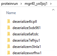
I'm not sure if this is limited to Civil 3D, or whether it applies to AutoCAD also. I'm starting to find that inside of user's %temp% folder, is a subfolder named "proteinrun", and inside this folder are tons of other folders, and inside each one of those, are more files and folders. On the few that I'm run across, there are thousands of files/folders sitting here, anywhere from 6-8 GB in total size. Ultimately, the files, when you finally drill your way to them, are .PNG files. I traced it back to Autodesk because of this KB article - which says it's related to Inventor, and that these files are deleted once Inventor closes. We are not using Inventor, and the files are not being deleted. I suppose it's possible that the files are not being deleted due to application crashing, but I was wondering if anyone else has run across this bloat?
-

How do I change the colour of my surface so it stands out from the exisitng topo
juicyorange posted a topic in Civil 3D & LDD
I am looking to add clarity to my models for my clients and one thing I think would help that would be to add colour to the models I have. Mainly I wanted the design to have some kind of bright colour and the existing topo to be a darker colour. Any insights into this would be greatly appreciated. Thanks, J -
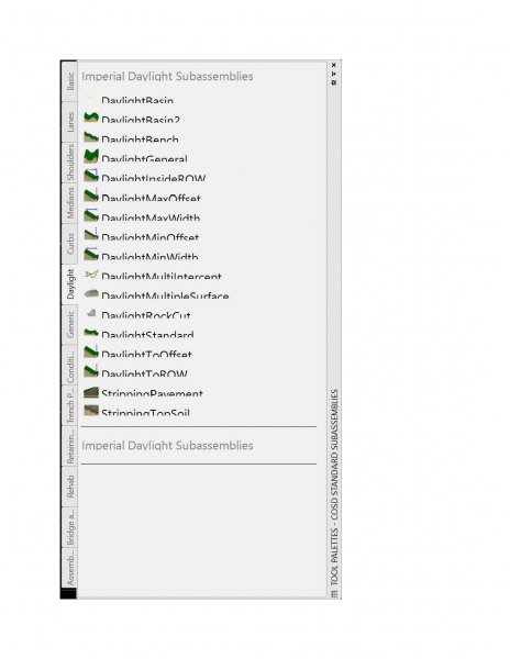
Hello, I am having trouble with the text size of the toolpalettes. All other items are just fine. If you have any suggestions it would be greatly appreciated. I am running 2016 and 2018, 2018 looks great, 2016 looks like the image below Regards, Phil
-
Hello, I have about 28 years of autocad experience, the last 10 being almost exclusively civil 3d. I am interested in adding revit to my skill set. Does anyone have a recommendation for tutorials? I know it took s bit of time to tackle c3d and I'm wondering what it will take to really get a handle on revit. Also, is anyone under the impression that revit will eventually 'absorb' c3d. Any and all input, personal experience and suggestions are greatly appreciated. Regards, Phil
-
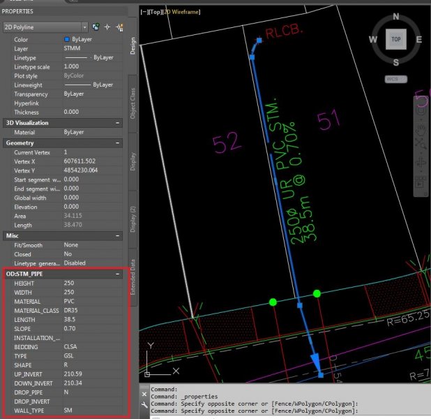
I need to add pipe properties to a 2D Polyline in AutoCAD or Civil 3D but I am not sure how to go about it. I have uploaded a sample file, the information I need to associate with the polyline is in the red box. If someone has any idea about adding these features to a 2D polyline please do let me know. Thank you Please find the sample file below
-
Using Civil 3D 2016 and having Intermittent Problems with not being able to remove items from the selection set. Anyone else having this problem? Terry Nolan www.FloridaDraftingServices.com www.1stProto.com 1stProto Design Services
-
I am working on a project that has dirtwork everyday that i need to run cut and fill quantities from daily asbuilts. Currently we are using Topcon Magnet Office DTM model (triangles), I am wondering if it will be more practical or accurate to use a Civil 3d surface to run these daily updates.
-
Hello All, Does anyone else have an issue with the command LAYUNISO? Every now and then when using this helpful command after using LAYISO it says that "Layers isolate by LAYISO command have been restored" but that is not always the case. Sometimes the layers are not restored and are left in a frozen state. To get the layers back on a LAYTHW or an UNDO is neccessary to get them back. This is counter productive because this adds extra work. Any layers previously frozen are turned back on or if you use the UNDO you have to redo the work. Any ideas? Thanks in advance. Miller
-
Hello, I need to specify the slope of the streets of a city. I have the elevation points of streets. But, how can I get slopes in Civil 3D? I am working with Civil 3D, but I do not know the procedure for this work. I should create a surface from these points? The surface's triangles must be inside streets (the line of streets should be as breaklines)? Thank you in advance, Mohsen
-
I am receiving error message "surfaces do not overlap" when i try to get volume between two surfaces.. i have two surfaces: 1. Made up of Survey points 2. Polyline which i put an elevation to make it 3d poly and then convert it into block before making it a surface. What could have I done wrong? Help me please
-
When using the Intersection Wizard in Civil 3D (2013) I get holes (spaces of non-filled in areas) in the intersection corridors that make up the intersection corridor. Why and how do I fix them?
-
Hi everyone, this is first time that I am posting on this forum, and I hope that I will get help. I am using Civil 3D 2014, and a couple days ago I changed my ATI HD 4850 with Nvidia GTX 570 2.5GB. And I did not noticed any improvement with new card! My road is about 5 km long, I have about 3000 points, surface, alignment and corridor are in different dwg files and are connected through Data Shortcuts. And I still have problem with viewing corridor in 3D orbit, even in 2D Wireframe everything is so slow, almost as when I had old 4850. Grip edit in alignment is simply impossible, superelevation edit is slow as it was before upgrade. I was hoped that I will get a better performance with GTX 570, since it is powerful card, but now I am very disappointed. So I am interested does any of you had experience with this GPU, did had similar problems with slow workflow of civil 3d, or problem is maybe in some other component. My cpu is Phenom II X4 960T, RAM 4GB 1800MHz DDR3 (it never goes over 60-70 % load), SATA HDD. I will be glad if someone could help me with proper advice, since I will not be happy if I should change my GPU again!
-
Hello People. Yesterday i downloaded AutoCAD CIVIL 3D 2015 in my Dell with windows 8. I was currently working with civil 3d 2013 and I appeared errors shareability with windows 8. A result of that I decided to download and install civil 3d 2015 by the shareability of windows 8. But when you start the application the pointer in the work area repeats me and gets stuck. as the picture shows. will be for some setting you need to disable or enable?. my dell have i7 4th generation. 8Gb RAM and 2gb Video Card. please help me!.. thanks..sorry for my english
-

import dng to dwg, cannot see all data in autoCAD.
faveo posted a topic in AutoCAD 3D Modelling & Rendering
Hi I am using autocad civil 3d 2010. I got .dng files (in 3d) from a customer. I was able to import the data to .dwg (no problem). However, some data seemed to be missing. The customer could see all data in microstation. He said I needed to change the display depth cause some z-number were -99999. That is probably why I cant see all data in autocad. My question now is how do I change the display depth in autocad? Has anyone else had the same problem where you cant see all data when you convert from dng to dwg? Did i do something wrong when I imported the files? Thank you and Im looking forward to read your comments.